Election Geodata
Precinct shapes (and vote results) for US elections past, present, and future
Download data
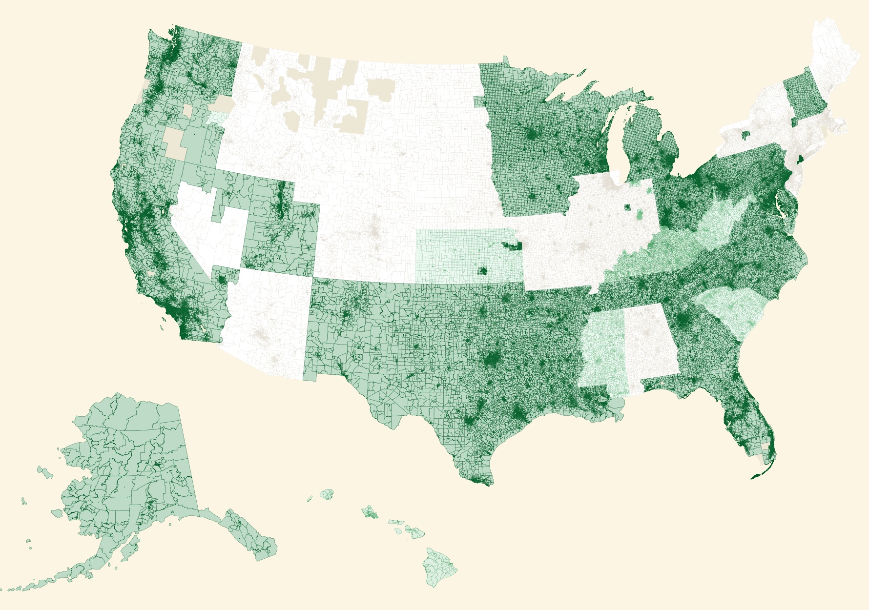
MAP KEY
- Dark green = newer 2016-2017 precincts
- Medium green = 2014-2015 precincts
- Light green = 2011-2012-2013 precincts
- Light brown = older 2010 precincts
- Medium brown = missing precincts
Background
I’ve been reading Mike Migurski’s excellent blog series 1 and 2, on US election data and redistricting and this repo is in repsonse to his call for better data.
For analysis to be rigorous, geographic shape data is needed at the precinct level, and vote results for local races like state house, state senate, and federal representative to the U.S. Congress is essential. They must be matched up per year, as precinct voting districts often change each election.
This repo is an effort to gather this essential data and distribute it as open data.
Gathering data
Please browse the issues attached to this Github repo to identify sources and import shapefiles for precincts. The goal is to have state-wide shapefiles for multiple dates corresponding to election years (like 2008, 2010, 2012, 2014, and 2016). Statewide is prefered, but county and city are also interesting.
If you also find election result information along the way my current thinking is it’s better to contribute to the Open Elections project directly, but maybe it’s easier to do that here and then link up over there later.
Possible Sources:
- State elections officials (eg secretary of state)
- Local (county) election officials (eg registrar of voters)
- Open Elections – a Github-based project by journalists Serdar Tumgoren and Derek Willis
- Data hackers and data journalists, like LA Times
- Census 2010 (src)
- For the 2010 Census, only Rhode Island did not participate in Phase 2 (the Voting District/Block Boundary Suggestion Project) of the 2010 Census Redistricting Data Program. Kentucky chose not to provide VTDs as part of their participation in Phase 2, and the states of Montana and Oregon provided VTDs for some counties. Therefore, for 2010 Census data products, no VTDs exist in select counties in Montana and Oregon or for the states of Rhode Island and Kentucky in their entirety.
Credits
No permission is needed to use Election Geodata. Crediting the project, authors, and linking back is recommended but not required.
Short text:
Source: election-geodata.
Long text:
Source: Precinct-level maps from election-geodata compiled by Nathaniel Kelso and Michal Migurski.
See also:
- baby steps towards measuring the efficiency gap - Mike’s follow-up post
- things I’ve recently learned about legislative redistricting - Mike’s original post
Building From Scratch
Code for building output maps, nationwide packages, and uploading downloadable files can be founder under docker/ directory.








评论